Agency of Mapping in South Asia: Galle-Matara (Sri Lanka), Mumbai (India) and Khulna (Bangladesh)
Introduction:
The territories cities and landscapes of South Asia are under incredible transformation due to manmade and natural conditions. As countries in the region are undergoing a process of decentralization and devolving responsibilities, spatial planning and urbanism are greatly affected particularly in terms of infrastructure provision, environmentally-responsive growth, and transformation, synchronization between government agencies, community participation, and institutional strengthening. Cities and their hinterlands are simultaneously reaping the benefits and pitfalls of the region’s near-universal endorsement of the neo-liberal urban development paradigm. Urban and rural cultures alike are overlaid with new spatial logics of global tendencies. There is enormous pressure from deregulated real estate speculation threatens the heritage of ancient urban fabrics as well as of neighboring fragile landscape ecologies, which is compounded by the fact that cash-strapped governments are retreating from the public realm.
South Asian cities and landscapes have been traveled to, mapped, chronicled, and described. The biographies of the territories remain dependent upon who was mapping and narrating and for what purpose. The cases investigated here – the southwest (Galle-Matara) coast of Sri Lanka, Mumbai, the economic engine of India, and Khulna (pop. 2.3 million), the third-largest city in Bangladesh, were significantly transformed into sites of geopolitical and economic importance during the colonial era – first by the Portuguese and British.
Mapping South-Asian cities and landscapes:
Throughout history, South Asian cities and landscapes have been travelled to, mapped, chronicled and described. The biographies of the territories remain dependent upon who was mapping and narrating and for what purpose. The cases investigated here – the southwest (Galle-Matara) coast of Sri Lanka, Mumbai, the economic engine of India, and Khulna, the third largest city in Bangladesh, were significantly transformed into sites of geo-political and economic importance during the colonial era – first by the Portuguese and British. All were territories where extreme world-view narratives and ideologies (political-economic models) were tested, spatialized and materialized. Cities and landscapes were carefully charted and maps of the period highlighted the strategic, infrastructural and instrumental implications of the landscape in relation to control and exploitation of the territory.
Territorial structuring:
Understanding the shifting relationships (smooth and conflictual) between landscape, infrastructure and urbanization became a base for descriptive (landscape) urbanism in the three contexts. The link of various qualities and opportunities of the territory to their typo-morphological settlements were mapped in order to gain insights into the logics of development.
Urban/rural tissues:
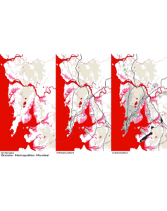
The major structuring elements of the cities and landscapes are relatively easy to identify whereas understanding the major built volume of all territories, the urban fabric – the often uncelebrated (predominantly residential) infill – is more complex. However, it can be argued that the anonymous fabric is at least as significant in defining the character and culture of any given territory as are the larger structures. To further understand the territories of Galle-Matara, Mumbai and Khulna, a 1969 method of fabric analysis – by Caminos, Turner and Steffian of Massachusetts Institute of Technology.
The ‘agency of mapping’ in South Asia:
South Asian cities are struggling to transform qualitatively. They are embroiled in the process of redefining their place in the world’s mental and physical landscapes. At the same time, urban development, at the regional and city-scale can no longer be controlled by the classical tools of the master plan, land use plan and building plan in the traditional sequence. As plans and zoning regulations are carefully designed, reality in the field follows its own logics. Changes in politics and economics have led to South Asian cities’ entry to globalization.
Conclusion:
The ‘agency of mapping’ is the beginning of design research; it aims towards the provisional synthesis of several factors and at multiple scales. Following an understanding of South Asia’s interdependencies of landscape, infrastructure and urbanism, it is possible to project new relationships. Through a dynamic interplay of urban visions and strategic projects designs can then make realistic, yet radical, amendments to the region’s project mode, which in its orientation towards the liberal private market has seemingly forgotten to provide public services to the majority of its inhabitants.